Rancho del Paso and Hacienda Alta

Gated Community: Quiet, Secure, Homes, Lots and Boarding Stable

RDP HOME

Directions to the Rancho

Air Service to Chapala

Photos & Drawings

Short Term Rental

Hacienda Alta development

Hacienda Alta House #1

Hacienda Alta subdivision

View Lots for Sale

Boarding Stables

Stables

Stable Rules and Boarding

Trails

Stables Construction

Compost for Sale

The Lake Chapala Area

Lakeside Equestrian Links

Bring a Horse to Mexico

Equine Friends in Mexico

Equestrian Supply Places

Equestrian Supplies

Bringing Our Horses Down

Contact Us

RDP FAQs and Answers

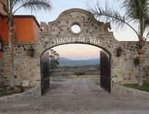
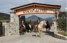
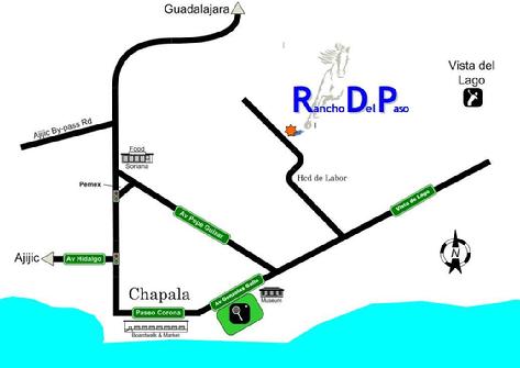
Local Directions to Hacienda Alta and Rancho del Paso

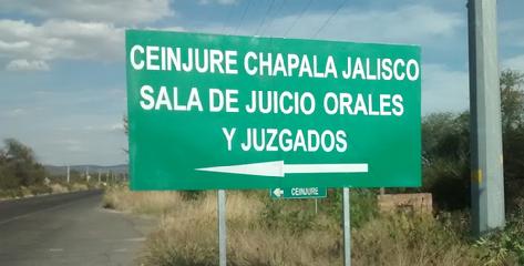
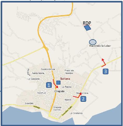
You want to get onto the road heading east out of Chapala along the lake towards Santa Cruz and Vista del Lago.  NOTE that you will turn left (north) up into the hills very soon after exiting Chapala - you will see the "O Shirt" store and a "Gas Butep" on your left, before the turn; and a big green sign with an arrow and “Ceinjure Chapala Jalisco” on the first line, where you turn left.  If you reach Santa Cruz, you've gone too far, turn around.

If you already know how to get on that road heading east of Chapala along the lake, jump to this section: "The Left Turn and the road up the hill"

 Entering Chapala from the north

When entering Chapala via the libramiento from Ajijic, or the highway south from Guadalajara - you'll go past the Soriana supermarket on your left.   Take the next turnaround in the road to head back up towards Soriana, and turn right onto Pepe Guizar before you reach Soriana. 

Follow Pepe Guizar to the end & turn left on to Gonzalez Gallo, you will be on a nice smooth asphalt road. At this point, follow the directions in this section: "The Left Turn and the road up the hill"

 Entering Chapala from the west (road along the lake from Walmart past SuperLake)

As you enter Chapala, there will be a big intersection at a stoplight with a fountain on your right.  Continue straight through that intersection and go straight through town until the road “T’s” on a big boulevard by Cristiana Park.  Take a left and go straight; eventually the cobbestones will change to a nice smooth asphalt road. At this point, follow the directions in this section: "The Left Turn and the road up the hill"

 Approaching from the east (Tlachimulco, Vista del Lago, San Nicolas etc)

You’ll see the same big green sign where you will turn right to go up the hill – so, follow the instructions below.


The Left Turn and the road up the hill

As you exit Chapala heading east the road will change from bumpy cobblestones to nice smooth asphalt, with restaurants on each side of you --  “La Letra CH” on the north, and the Penguinos seafood shack on the lake side. 

Follow that asphalt out of town to the east for 1.1 miles.  Just before the turn, you’ll see “O Shirt” on your left, followed by Gas Butep. 

Turn left at the big green sign with an arrow pointing left, it says “Ceinjure Chapala Jalisco” on the top line  – That’s the first major road to your left.   


Big Green sign at the turn onto our road

Follow the asphalt road up the hill for 1.0 mile, proceeding over  the potholes and a " right, left” S-curve which is the tiny village of Hacienda La Labor, to the top of the hill.

Look for a BIG  stone wall on right, covered with bougainvilleas – there are entrance gates at the south end and north end.  The south (first) gate is for the Hacienda Alta subdivision;  the north (second) gate, says Rancho del Paso on top of the gate and has an intercom to the stables and owners' house.

Entrance to Hacienda Alta
Rancho del Paso Entrance
Map from Chapala, noting the turns

For Out of Towners

Hacienda Alta and Rancho del Paso are located just east of the town of Chapala, Mexico, on the north shore of Lake Chapala, the largest lake in Mexico.  Lake Chapala is 45 minutes south of Guadalajara, the second largest city in Mexico.  "Guad", as the locals refer to it, is a cosmopolitan metropolis featuring all the city amenities one would expect from a first world city--culture, shopping, night life, first class medical facilites and business services.  Guadalajara International Airport (GDL) is served by a number of U.S., Mexican & International airlines, and features direct service to numerous cities in the U.S. and Canada.  And best of all, the airport is south of Gaudalajara, so once you land, you're only 30 minutes from Hacienda Alta and Rancho del Paso.  As shown on the map below, the Rancho is easily accessible from the Guadalajara-to-Chapala highway, and downtown Chapala.    

Road map to RDP

It is only a 12 - 15 minute drive from the Walmart in Ajijic, to the gates of RDP.  Less than 10 minutes to the golf course at Vista del Lago (further east), the tennis courts at Cristiana Park, the Gonzalez Gallo Cultural Center, the Chapala Malecon, and stores such as Pharmacia Guadalajara and Soriana.